| Welcome to my Chewacla State Park trails web page |
|---|
| Home | Gallery |
| Hiking |
Welcome to my web page for the Chewacla State Park trails. This is another trail out of the Passport to Fitness program. I hiked the Mountain Laurel trail (trail 7) Sunday (May 16, 2010). The trail description, according to the park, is "Mountain Laurel Trail - The Mountain Laurel Trail begins at the Upper Pavilion area, goes down to Chewacla Falls and then follows Chewacla Lake. The trail has several connecting trails that lead back to the Upper Pavilion area. This trail takes about 1 hour to complete." You will find pictures and descriptions from my walk below. If you have any comments or questions please feel free to drop me an email through the link below. Enjoy! :) |
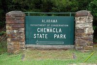
| Here's the entrance sign to the park. You can use the following coordinates to get to this park: N 32° 33' 15.6" W 085° 28' 53.3". |
|
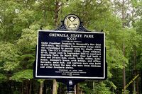
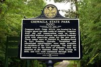
Just inside the park entrance are several historical markers. The first one reads, Company 4447, Camp SCS-9, was located in Lee County about one mile south of Auburn. Company 4447 did soil conservation work on farms, controlled highway erosion, and assisted Company 4448 with quarrying stone for the new park. These camps were in District H, headquartered in Fort Benning, Georgia. Vocational and eduational opportunities were made available to enrollees of the CCC program. The park was turned over to the State of Alabama, with the creation of the Alabama State Park System in 1939, and CCC work continued through 1941." |
 |
 |
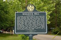
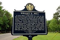
A little further down the road you will find another marker. This one reads, In early 1890's a club house was built on the hill between Wright's Mill and the Gin-Saw Hole. This was a favorite recreation area for Auburnites before Town Creek was contaminated by Auburn sewage. A bicycle club was formed in Auburn circa 1900. George Petrie and B.B. Ross were prominent members. A bicycle path was constructed from Auburn to Wright's Mill. It began where Gay Street formerly terminated at Samford Avenue following the east bank of Town Creek much of the way. Chewacla State Park was opened in 1939 and this park includes the Wright's Mill area." |
 |
 |
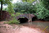
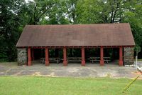
| Driving through the park you will cross the arch bridge. The road ends atop a hill. There is a large, open field for various activities. You will also find a pavillion here that overlooks the valley and creek below. |
 |
 |
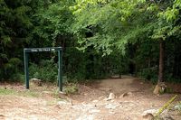
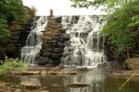
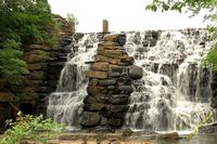
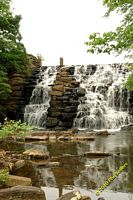
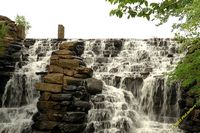
| From the trailhead it is a short, down-hill walk to the dam. Below the down is plenty of opportunity for wading in the creek or climbing on the rocks. From the dam you will continue following the trail heading North-Northeast. You will find several connecting trails along the way or you can walk beside the lake until you come out of the woods by the arch bridge. |
 |
 |
 |
|
 |
 |
Last Updated: March 23, 2012
Updates to this page:
|
|
|
| Questions or comments? |
| All content and images © Copyright 2010 Phil Sellers |